The perceived safety and tranquility of the suburbs is a dangerous illusion when it comes to flooding.
- Low-density sprawl, characterized by vast, non-absorbent surfaces like roads and driveways, dangerously amplifies rainwater runoff, turning moderate storms into destructive flash floods.
- The very infrastructure designed for convenience becomes a massive financial liability for municipalities and a direct threat to homeowners, concentrating systemic risk in areas never designed to manage it.
Recommendation: Homebuyers must look beyond the curb appeal and analyze a neighborhood’s hydrological resilience and its municipality’s infrastructure debt to avoid a devastating financial loss.
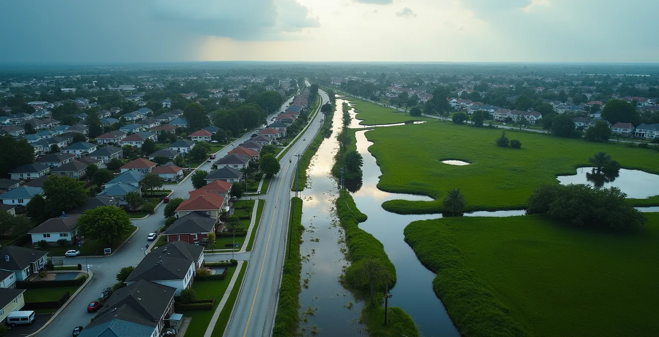
The forecast calls for heavy rain, and as a suburban homeowner, you watch the clouds gather with a familiar sense of unease. You’ve been told the increasing frequency of these “100-year storms” is the new normal, a direct consequence of a changing climate. While climate change is undeniably a powerful factor, it’s a convenient and incomplete explanation. It obscures a more immediate and controllable culprit for why your street is more likely to flood than ever before: the very design of your neighborhood.
The sprawling, low-density suburb—often marketed as a safe haven from the chaos of the city—is a deeply flawed system from a hydrological perspective. The endless ribbons of asphalt, the wide concrete driveways, and the massive rooftops all contribute to a landscape that repels water instead of absorbing it. This creates what urban planners call an “infrastructure liability”—a built environment that is not only expensive to maintain but actively magnifies natural hazards. While we blame the storm, we ignore the man-made decisions that turned a manageable rainfall into a catastrophic flood.
But what if the key to resilience wasn’t just bigger storm drains or higher flood walls? What if the solution lay in fundamentally rethinking the DNA of our suburbs? This article will dissect the systemic risks embedded in urban sprawl. We will explore the science of why concrete is a catalyst for flooding, analyze the costly zoning mistakes that burden municipalities, and uncover the practical, green-infrastructure solutions that can retrofit these vulnerable communities into resilient, water-wise neighborhoods. It’s time to look past the manicured lawns and understand the concrete reality of flood risk.
To fully grasp the interconnected nature of this issue, this guide breaks down the problem from the physics of a single raindrop to the macro-economic consequences of municipal planning. Follow along as we unpack the hidden vulnerabilities of suburban life.
Summary: Unpacking the Financial and Environmental Costs of Sprawl
- Why Does Concrete Paving Increase Surface Runoff by 50% During Storms?
- How to Design Mixed-Use Neighborhoods That Reduce Car Dependency?
- High-Rise vs Sprawl: Which Model Has a Lower Carbon Footprint per Capita?
- The Zoning Mistake That Bankrupts Municipalities via Road Maintenance Costs
- How to Retrofit Sprawling Suburbs into Walkable Communities in 10 Years?
- Why Does Real-Time Data Change Consumer Behavior More Than Monthly Bills?
- Why Is Downtown 4°C Hotter Than the Suburbs at Night?
- How to Create Cool Local Microclimates in Heat-Stressed Urban Gardens?
Why Does Concrete Paving Increase Surface Runoff by 50% During Storms?
The fundamental problem with urban sprawl is one of simple physics and surface area. In a natural, undeveloped environment like a forest or meadow, the ground acts as a massive sponge. Rain falls, and the vast majority is absorbed into the soil, replenishes groundwater, and is slowly released into streams. In contrast, urban and suburban landscapes are dominated by impervious surfaces—materials like concrete and asphalt that do not allow water to pass through. This distinction is not trivial; it is the root cause of urban flooding.
This paragraph introduces a complex concept. To understand it better, it is useful to visualize its components. The illustration below breaks down this process of water behavior on different surfaces.

As this visual starkly demonstrates, the outcome is drastically different. Engineering calculations show the dramatic contrast: while wooded areas have a runoff coefficient of just 0.15 (meaning only 15% of rain runs off), concrete surfaces have a coefficient of 0.95. This means 95% of the rainwater becomes immediate, high-velocity runoff. This water, carrying pollutants from the streets, rushes into storm drain systems that were often designed for a much less developed landscape. When the volume of this runoff exceeds the system’s capacity, flooding is the inevitable result. This isn’t a freak accident; it’s a predictable system failure. A study of Hurricane Harvey in 2017 found that Houston’s risk for extreme flooding was 21 times greater specifically due to urbanization, contributing to an estimated $125 billion in damages.
How to Design Mixed-Use Neighborhoods That Reduce Car Dependency?
If impervious surfaces are the problem, then reducing them is the solution. This goes beyond simply planting more trees; it requires a fundamental shift in how we design our communities. The sprawling, single-family-home model is inherently inefficient, demanding vast networks of roads and parking lots that are the primary sources of impervious cover. A more resilient alternative lies in creating dense, walkable, mixed-use neighborhoods where residential, commercial, and recreational spaces are co-located.
This model drastically reduces the need for cars and, consequently, the amount of land dedicated to parking and wide roads. By building up rather than out, we can preserve more open, permeable green space. The impact is quantifiable and significant. A comprehensive study analyzing flood data reveals that for every percentage point increase in impervious surfaces, annual floods increase by 3.3%. Designing for walkability is not just a lifestyle amenity; it’s a critical flood mitigation strategy. This involves not only zoning changes but a conscious effort to integrate green infrastructure directly into the urban fabric.
Action Plan: Key Strategies for Resilient Mixed-Use Design
- Permeable Parking: Replace traditional asphalt parking lots with permeable pavers or reinforced grass systems that allow rainwater to infiltrate directly into the ground.
- Green Roofs and Walls: Mandate or incentivize the installation of green roofs on new and existing buildings to absorb rainwater, reduce runoff, and combat the urban heat island effect.
- Shared Parking Structures: Design shared, multi-level parking garages to serve multiple businesses, drastically reducing the surface footprint compared to individual lots for each establishment.
- Integrated Bioswales: Incorporate landscaped drainage channels (bioswales) and rain gardens into streetscapes and public spaces to capture, filter, and slowly release stormwater.
- Pervious Pavements: Utilize pervious concrete or porous asphalt for sidewalks, bike lanes, and low-traffic areas, turning transportation corridors into functional parts of the water management system.
By implementing these strategies, developers and city planners can transform neighborhoods from sources of runoff into active components of a distributed, natural drainage system, significantly lowering flood risk for everyone.
High-Rise vs Sprawl: Which Model Has a Lower Carbon Footprint per Capita?
The debate between high-density towers and low-density sprawl often centers on lifestyle or aesthetics. However, when viewed through the lens of environmental impact, the data becomes clear. While the question is often framed around carbon footprint—where density almost always wins due to reduced transportation needs and more efficient heating/cooling—an equally critical, yet often overlooked, metric is the hydrological footprint. On this front, the case against sprawl is overwhelming.
Sprawl is, by definition, land-intensive. Each new home requires its own driveway, its own patch of non-absorbent lawn, and its share of the vast road network connecting it to distant services. This cumulative impact is staggering. For instance, research from Qatar demonstrates that between 1984 and 2020, urban areas grew by a shocking 777%, which directly caused surface runoff to increase by 422%. High-density development, in contrast, concentrates its physical footprint, leaving far more of the surrounding landscape in its natural, water-absorbing state. This allows for the implementation of large-scale, highly efficient green infrastructure solutions at a district level, rather than relying on a patchwork of small, disconnected efforts on individual lots.
The following table, based on hydrological modeling, starkly compares the per-capita impact of these two development models. It’s a clear illustration of how individual living choices scale up to create massive systemic risk.
| Development Model | Impervious Surface per Capita | Runoff Coefficient | Green Infrastructure Potential |
|---|---|---|---|
| High-Rise Development | 0.05 hectares | 0.40-0.50 | High (district-scale solutions) |
| Suburban Sprawl | 0.20 hectares | 0.70-0.85 | Low (fragmented lots) |
The conclusion is unavoidable: from a water management perspective, suburban sprawl is a far more destructive and risky model of development than concentrated, high-rise living.
The Zoning Mistake That Bankrupts Municipalities via Road Maintenance Costs
The most insidious aspect of urban sprawl is that it creates a long-term financial trap for both homeowners and the municipalities that serve them. The problem lies in single-use zoning—the practice of separating residential areas from commercial and industrial zones. This forces the creation of vast, sprawling road networks, as everyone must drive everywhere for everything. Initially, these roads are funded by development fees and a growing tax base. But infrastructure doesn’t last forever.
As Gabriel Vecchi of Princeton University’s Environmental Institute warns:
For every new roadway poured and for every new high-rise erected, there is an increased risk for more adverse rainfall and flooding, and that’s certainly something that city officials and residents should consider when they contemplate future growth.
– Gabriel Vecchi, Princeton University Environmental Institute Study
This new infrastructure creates an “infrastructure liability.” After 20-30 years, these roads, pipes, and drains begin to fail, and the tax revenue generated by the low-density development is rarely sufficient to cover the enormous cost of replacement. The municipality is effectively bankrupt, forced to either raise taxes dramatically or let essential services decay. This decay directly increases flood risk. Furthermore, the development choices themselves are often more impactful than the weather. A startling analysis of Salt Lake City found that an 18% increase in imperviousness has a greater impact on flooding than a 25% increase in rainfall intensity. Our zoning choices are creating a problem that no amount of engineering can affordably fix.

The idyllic image of the quiet cul-de-sac hides this fiscal reality: a system designed for initial profit but long-term insolvency, with homeowners ultimately bearing the cost through higher taxes and increased flood risk.
How to Retrofit Sprawling Suburbs into Walkable Communities in 10 Years?
While the picture for existing suburbs seems bleak, it is not hopeless. The concept of “gray-to-green retrofitting” offers a pathway to transform these hydrologically inefficient landscapes into more resilient, walkable communities. This process involves strategically identifying underutilized “gray” infrastructure—like oversized roads, dead-end cul-de-sacs, and vast parking lots—and converting them into functional “green” infrastructure.
The goal is to reintroduce permeability into the landscape, piece by piece. This could mean converting a redundant traffic lane into a landscaped bioswale that absorbs and filters street runoff. It could involve transforming the bulb of a cul-de-sac into a community rain garden. On a homeowner level, it means replacing traditional concrete driveways with permeable pavers. These are not merely cosmetic changes; they are critical interventions that begin to reverse the hydrological deficit created by decades of poor planning. The urgency is underscored by consistent findings that urban streams rise more quickly during storms and have higher peak discharge rates than their rural counterparts, a direct result of the impervious surfaces we’ve built.
A 10-year timeframe is ambitious but achievable with a combination of municipal policy, developer incentives, and homeowner action. It requires a new way of seeing the suburban landscape—not as a finished product, but as a canvas for incremental, positive change. Every patch of asphalt removed, every curb cut that directs water to a tree pit, and every downspout disconnected from the storm drain and routed to a rain barrel is a small victory in the larger battle for resilience. It is the slow, deliberate work of healing the land, one parcel at a time.
Why Does Real-Time Data Change Consumer Behavior More Than Monthly Bills?
A crucial element in building resilience is empowering residents with actionable information. A monthly water bill or a generalized flood risk map is a lagging indicator; it tells you about a problem long after the fact. To drive meaningful change in behavior, data needs to be immediate, personal, and understandable. This is where real-time monitoring systems come into play, transforming abstract risks into tangible, immediate feedback loops.
Imagine a mobile app that sends a push notification not when a flood warning is issued for the entire county, but when a sensor in your local storm drain detects a flow rate approaching its capacity. This kind of hyperlocal data could prompt residents to move valuables, check their sump pumps, or avoid certain roads. Cities like Phoenix have been pioneers in this area, recognizing that progressive stormwater management policies require high implementation and constant monitoring. When homeowners can see, in real-time, how a heavy downpour affects runoff in their immediate vicinity, the abstract concept of “impervious surfaces” becomes a concrete reality.
Implementing such a system involves a strategic deployment of technology and a commitment to open data. Key steps include:
- Installing stream gauges at critical drainage points throughout the suburban watershed.
- Deploying Internet of Things (IoT) sensors in storm drains to monitor flow and detect blockages.
- Creating public-facing online dashboards that visualize this real-time data for residents and emergency responders.
- Developing mobile applications that deliver hyperlocal flood alerts based on sensor readings.
- Engaging residents through citizen science programs to collect data, such as mapping areas of high soil compaction in public parks.
This flow of real-time information closes the gap between cause and effect, empowering homeowners to become active participants in their community’s resilience rather than passive victims of a flawed system.
Why Is Downtown 4°C Hotter Than the Suburbs at Night?
The same materials that cause flooding—asphalt, concrete, and dark roofing—are also responsible for another dangerous urban phenomenon: the Urban Heat Island (UHI) effect. These surfaces absorb and retain solar radiation during the day and then slowly release that heat at night. This is why a dense downtown core can be several degrees hotter than the surrounding leafy suburbs, creating significant health risks during heatwaves.
However, as suburbs themselves become more densely paved, they begin to create their own smaller, localized heat islands. This creates a dangerous synergy with flood risk. The increased heat stresses the limited green spaces, causing soil to dry out and become less absorbent, which can paradoxically increase runoff when a storm finally arrives. This twin threat, where the landscape is both hotter and more flood-prone, is the direct result of our development choices, amplified by a changing climate. As researchers from the University of Maryland and Texas A&M aptly summarized the issue:
First, urban sprawl consumed natural drainage areas and altered the way water flowed through cities. Second, climate change increased the frequency and severity of extreme rainfall events.
– University of Maryland and Texas A&M Researchers, The Growing Threat of Urban Flooding Report
The heat island effect also places additional strain on infrastructure and increases energy consumption as demand for air conditioning rises. It’s a feedback loop where the built environment exacerbates an environmental problem, which in turn degrades the built environment and quality of life. The heat rising from the pavement after a summer rain is a physical manifestation of this systemic dysfunction.
Key Takeaways
- Impervious Surfaces are the Primary Culprit: The core driver of increased flood risk in suburbs is the replacement of absorbent natural ground with non-porous materials like concrete and asphalt, which can increase runoff by over 500%.
- Low-Density Design is Financially Unsustainable: The sprawling model creates a long-term “infrastructure liability,” where the high cost of maintaining vast road and drainage networks eventually outstrips the tax base, leading to decay and increased risk.
- Green Retrofitting is the Path Forward: The only viable long-term solution is to strategically reintroduce permeability into the landscape by converting “gray” infrastructure (excess pavement) into “green” infrastructure (bioswales, rain gardens, permeable surfaces).
How to Create Cool Local Microclimates in Heat-Stressed Urban Gardens?
Faced with the systemic issues of sprawl, heat, and flooding, it can be easy for a homeowner to feel powerless. However, individual properties can become part of the solution by being redesigned as “sponge gardens.” This approach treats a yard not as a decorative, non-absorbent carpet of grass, but as a small, functional ecosystem designed to capture, hold, and slowly release water while simultaneously creating a cooler microclimate.
The principle is simple: slow the water down, spread it out, and let it soak in. This is the opposite of a traditional drainage system, which is designed to get water off the property as quickly as possible. A sponge garden might feature a small depression or “rain garden” strategically placed to capture runoff from a roof or driveway. It would be planted with deep-rooted native plants that are adapted to both wet and dry conditions, helping to draw water deep into the soil. Amending the soil with compost and using layers of mulch helps to maximize its water-holding capacity and reduce evaporation. The impact of many such individual actions can be significant, especially when you consider that urban areas can have five times the runoff of a typical woodland of the same size. Each yard converted into a sponge helps chip away at that deficit.
Creating these microclimates involves several key strategies: installing rain barrels connected to downspouts, designing shallow swales along property lines to slow and direct water flow, and choosing plant species that provide shade and transpire water to cool the surrounding air. This not only reduces the volume of water hitting the municipal storm drain but also creates a more pleasant, resilient, and biodiverse space. It is a tangible way to fight back against the negative effects of the surrounding gray infrastructure, turning a single plot of land into an oasis of resilience.
The evidence is clear: the American suburban dream, as currently designed, rests on a crumbling and hydrologically unsound foundation. As a prospective homebuyer or a current resident, you must become your own advocate. Before you invest your life savings, look beyond the facade. Investigate the municipality’s long-term infrastructure maintenance budget. Use online flood map tools, but understand their limitations. Most importantly, walk the neighborhood after a heavy rain and see for yourself: where does the water go? Your financial security and physical safety depend on looking past the green lawn and seeing the concrete reality of water management.